


Nearby Cities: Piedmont
Calhoun County
The Chief Ladiga Trail extends 32.5 miles from the Georgia state line to Weaver, Alabama. It is a paved recreational trail on the bed of the former Seaboard/CSX Railroad and extends into Georgia an additional 63 miles, making it the longest continuous …
learn more
Nearby Cities: Borden Springs, Piedmont
Cleburne County
The Chief Ladiga Trail extends 32.5 miles from the Georgia state line to Weaver, Alabama. It is a paved recreational trail on the bed of the former Seaboard/CSX Railroad and extends into Georgia an additional 63 miles, making it the longest continuous …
learn more
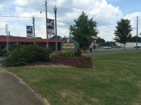
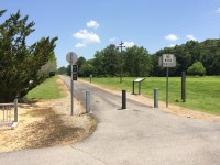
Nearby Cities: Jacksonville
Calhoun County
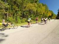
The Chief Ladiga Trail extends 32.5 miles from the Georgia state line to Weaver, Alabama. A paved recreational trail, it follows the bed of the former Seaboard/CSX Railroad. It extends into Georgia an additional 63 miles along the Silver Comet Trail, m …
learn more
Nearby Cities: Jacksonville
Calhoun County
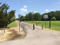
The Chief Ladiga Trail extends 32.5 miles from the Georgia state line to Weaver, Alabama. A paved recreational trail, it follows the bed of the former Seaboard/CSX Railroad. It extends into Georgia an additional 63 miles along the Silver Comet Trail, m …
learn more


Nearby Cities: Camden
Wilcox County
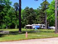
Chilatchee Creek Park and Campground sits adjacent to the 27-mile-long Dannelly Reservoir. The woods are a pine-oak mix of varying densities. The central part of the park is largely open, mature canopy with a grassy understory, while the periphery of …
learn more

Nearby Cities: Anniston
Calhoun County
Totaling 4,083 acres sandwiched between the cities of Oxford and Anniston, Coldwater Mountain is protected under Alabama’s Forever Wild Land Trust and is managed by Alabama State Lands. While there are abundant hiking and wildlife watching opportunitie …
learn more
Nearby Cities: Citronelle
Mobile County
In 1775, English botanist William Bartram made a trip to Citronelle to secure leaves of the collinsonia canadensis, which is a citronella plant used in tea that was believed to have curative powers over fever. English settlers came to Citronelle in 181 …
learn more
Nearby Cities: Pell City
St. Clair County
learn more
Nearby Cities: Coaling
Tuscaloosa County
learn more
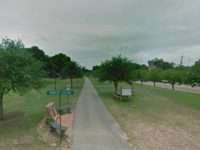
Nearby Cities: Huntsville
Madison County
The Land Trust is passionate about preserving lands for public use and encouraging residents and visitors alike to connect with the wonders of the natural world.Huntsville installed a series of signs from Big Spring Park along 1.2 miles streets that le …
learn more
Nearby Cities: Anniston
Calhoun County

With 4,083 acres located between the cities of Oxford and Anniston, Alabama’s Forever Wild Land Trust protects Coldwater Mountain. Alabama State Lands, part of the Alabama Department of Conservation and Natural Resources, manages the park. There are ma …
learn more
Nearby Cities: Paint Rock
Jackson County
learn more
Nearby Cities: Adalusia
Covington/Escambia County
The Conecuh National Forest is the southern-most national forest in Alabama, encompassing 84,000 acres between Andalusia, Alabama, and the Florida line. This public-land jewel supports prime examples of habitats and associated species found in natural …
learn more
Nearby Cities:
County
Birders and nature lovers are often left to observe from a roadside or property boundaries. Connecting with Birds and Nature Tours offers an opportunity for them to come to a private property where they can participate in tours or meander through 6 mil …
learn more
Nearby Cities: Clio
Barbour County
learn more
Nearby Cities: Clio
Barbour County
learn more

Nearby Cities: Guntersville
Marshall County
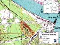
Cooley Cemetery Trail is located on TVA’s Guntersville Reservoir in Northern Alabama and is part of the Cave Mountain Small Wild Area. If you want to develop some endurance this is a good trail to pursue on foot or wheels—or you can experience it from …
learn more
Nearby Cities: Wetumpka
Elmore County
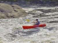
The Creek Indian word Wetumpka meant “rumbling waters” and you’ll see what they meant when you try the six-mile stretch of Coosa River Whitewater, known as Moccasin Gap, between Jordan dam and the town that is a rite of passage for thousands of Alabama …
learn more
Nearby Cities: Rockford
Coosa County
The Coosa WMA hiking trail is a moderate trail with plenty of views for hikers. The 11-mile trail has parking at both ends of the trail and two primitive campsites for people to stay overnight. Approximately 10 miles north of the Coosa trail, hikers ca …
learn more
Nearby Cities: Huntsville
Madison County
Land Trust of North Alabama’s Wade Mountain Nature Preserve is currently 843 acres with eight miles of trails for hiking, biking, or horseback riding. Wade Mountain is currently the only Land Trust Preserve which allows equestrian trail riding. A Recre …
learn more
Nearby Cities: Weogufka
Coosa County
learn more
Nearby Cities: Weogufka
Coosa County
learn more
Nearby Cities: Weogufka
Coosa County
learn more
Nearby Cities: Weogufka
Coosa County
learn more
Nearby Cities: Goodwater
Coosa County
learn more
Nearby Cities: Montgomery
Montgomery County
learn more
Nearby Cities: Montgomery
Montgomery County
learn more
Nearby Cities: Montgomery
Montgomery County
learn more
Nearby Cities: Auburn
Lee County
Entrance includes a ramp that leads to a path; which travels over a banked boardwalk around Volkswagen Rock, and follows the old vertigo inducing CCC-created trail along the creek. Beautiful vistas of the creek can be seen; along with lichen-covered ro …
learn more
Nearby Cities: Birmingham
Jefferson County
This trail has moderate inclines and can be accessed from the Ridge & Valley Trail or the Quarry Trail. It ends at a large iron ore rock crusher used during Ruffner’s mining years.
learn more
Nearby Cities: Guntersville
Marshall County
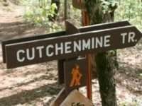
Cutchenmine Trail at Lake Guntersville State Park is approximately 2.25 miles in and out, for about 4.5 miles total distance. It is primarily double track, with a solid base and moderate terrain. There are several climbs, but the effort is worth it! En …
learn more
Nearby Cities: Vaughn
Baldwin, Mobile County
Traveling down Tensaw Lake this trail provides the opportunity to explore the backwater sloughs and tributaries of Tensaw Lake. This camping platform area has two platforms and can accomodate a larger group. Courtesy: Alabama Canoe Trails Website
learn more
Nearby Cities: Auburn
Lee County
The Deer Rub Trail begins at the Upper Pavilion as you hike down to Chewacla Falls and follows Chewacla Creek to the logging road across from the Walnut Shelter. Another point of entry to the Deer Rub Trail begins on the east side of the overlook and j …
learn more
Nearby Cities: Delta
Clay, Cleburne County
There are 5 trails on the east side of the park that were created as bike trails. Hikers are also welcome on these trails, but they need to yield to mountain bikers. The trails that you will encounter on the east side include: Cheaha Express, Deer Run, …
learn more
Nearby Cities: Fort Payne
Dekalb County
This trail is best accessed from the Gilliam Loop Trailhead>CCC Road>Exit 3. This trail serves as a shortcut between Exit 3 and Exit 4, and it follows along the ridge. It is not used much
learn more
Nearby Cities: Demopolis
Marengo County
learn more
Nearby Cities: Fort Payne
Dekalb County
The Lost Falls and Cascade Falls waterfall is the hardest to find in DeSoto State Park, mostly because when no water is flowing, it is truly lost! The best time to see this small 5 foot waterfall is in the Spring or Winter seasons. Lost Falls is locate …
learn more